Eastern Mojave Vegetation
Tom Schweich
|
Eastern Mojave Vegetation
| County Route G14 |
|
Tom Schweich |

|
(No Preface) |
|
Other articles:
|
Junction: US Highway 101, north through the Salinas Valley, or south through King City to San Luis Obispo and Los Angeles. |
| Junction: Oasis Road | |
| Junction: San Lucas Road | |
| Pass, 1,514 feet. | |
| Fort Hunter-Liggett border. | |
| Junction: Sulphur Springs Road | |
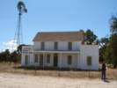
 Dutton Hotel at Jolon Dutton Hotel at Jolon
|
Dutton Hotel |
| Junction: Lockwood-Jolon Road. | |
|
Other articles:
Locations:
Jolon.
|
JolonJunction: Mission Road, west into Fort Hunter Liggett and Mission San Antonio de Padua. |
| Fort Hunter-Liggett border. | |
| Martinus Corner. Junction: Jolon-Pleyto Road, Cross Road | |
|
Other articles:
|
Junction: Lockwood-Jolon Road, County Route 18 County Route G-14 turns south at this intersection, winding its way past San Antonio and Nacimiento Reservoirs en route to Paso Robles. County Route G-18 is a more direct route to US Highway 101 near Bradley. |
| Junction: Jolon-Pleyto Road. | |
| San Antonio River. | |
| Junction: San Antonio Road. | |
|
Monterey County above San Luis Obispo County below | |
| Junction: Interlake Road. | |
| Nacimiento Dam | |
| Junction: Chimney Rock Road, also to Adelaida and beyond. | |
| Junction: San Marcos Road. | |
|
Other articles:
|
Junction: Adelaida Rd., to Adelaida. |
|
Other articles:
|
Junction: Spring Street as 24th Avenue |
|
Other articles:
|
Junction: US Highway 101 |
| If you have a question or a comment you may write to me at: tas4@schweich.com I sometimes post interesting questions in my FAQ, but I never disclose your full name or address. |
Date and time this article was prepared: 4/14/2024 5:26:38 PM |