Eastern Mojave Vegetation
Tom Schweich
|
Eastern Mojave Vegetation
| New York Mountain Road - Mojave National Preserve |
|
Tom Schweich |

|
(No Preface) | ||||||||||||||||||||||||||||||||||
|
Other articles:
|
Junction:
|
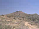 Miocene pyroclastic rocks on the south flank of the New York Mountains. Miocene pyroclastic rocks on the south flank of the New York Mountains.
|
|
Literature Cited:
Other articles:
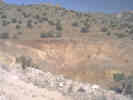
| Golden Quail MineThe small hills at the mouth of Caruthers Canyon, in the southwest corner of New York Mountain Road and Caruthers Canyon Road have some very interesting and accessible examples of geology. The claims are currently known as the Golden Quail claims. Hewett (1956) describes this area as follows:
|
|
|
This area is now known as the Golden Quail mine.
Ore was being hauled to the mill at the former Vanderbilt
Mine on Ivanpah Road.
However, they last time I visited this area the mine and mill were inactive.
However, if you visit, be careful of possible hazardous conditions.
|
|
Literature Cited:
Other articles:
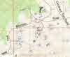
This is my field sketch map of the surficial geology I found during a day's visit.
|
|
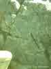 Metasandstone. Metasandstone.
This picture, and the next two were taken on the first hill south of New York Mountain Road, and north of the Golden Quail mine. It shows the swirling deformed bedding planes in the metasandstone.
|
|
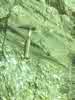 Metaconglomerate. Metaconglomerate.
There are numerous outcrops of meta-conglomerate in this area. Conglomerate is a sedimentary rock of sand and rounded gravel. When it is slightly metamorphosed by heat and pressure, the mineral grains interlock between the gravel and the sand, so it becomes a single rock called "metaconglomerate" with a texture that looks like sand and gravel. When the rock is fractured, as the rock face is in this photograph, the fracture cuts right through what used to be individual pebbles, giving this natural terrazzo effect.
|
|
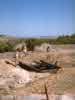
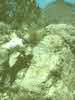 Slickensides near Golden Quail mine. Slickensides near Golden Quail mine.
George Hilton examines some exposed slickensides in a small adit on the east side of the hill. Perhaps this is one trace of the Cedar Canyon Fault.
|
|
Literature Cited:
Other articles:
Locations: Golden Quail Claims.
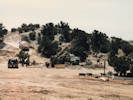
| This is the shaft that Hewett (1956) notes is 250 feet deep. Kate, Scott, Matt, and Linda are looking at the owl chicks in a nest about 6 feet down the shaft. The shaft is gone now as the current operators of the Golden Quail mine have dug an open pit about 30 feet deep. The stake in the right foreground marked a bore from which cores had recently been taken. None of the cores were left at the mine location.
|
Other articles:
Junction:
|
|
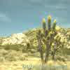 Joshua trees(Yucca brevifolia) in bloom near Caruthers Canyon Joshua trees(Yucca brevifolia) in bloom near Caruthers Canyon
A photo of Joshua Trees in bloom near Caruthers Canyon.
|
|
Locations:
Lanfair Valley.
|
|
 New York Mountain Road in Ross Horse Pasture. New York Mountain Road in Ross Horse Pasture.
Ross Horse Pasture
|
|
Literature Cited:
Other articles:
Junction:
|
If you have a question or a comment you may write to me at:
tomas@schweich.com
I sometimes post interesting questions in my FAQ, but I never disclose your full name or address.
|
|
Date and time this article was prepared: 4/21/2025 8:15:53 PM |