Eastern Mojave Vegetation
|
Eastern Mojave Vegetation
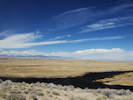
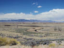
| San Luis Valley, Alamosa County, Colorado. |
|
Gazetteer Query: G.N.I.S.
|
||
|
The San Luis Valley is an extensive high-altitude depositional basin in the U.S. state of Colorado with a small portion overlapping into New Mexico covering approximately 8,000 square miles (21,000 km2) and sitting at an average elevation of 7,664 feet (2,336 m) above sea level. The valley is a section of the Rio Grande Rift and is drained to the south by the Rio Grande, which rises in the San Juan Mountains to the west of the valley and flows south into New Mexico. The valley is approximately 122 miles (196 km) long and 74 miles (119 km) wide, extending from the Continental Divide on the northwest rim into New Mexico on the south. The San Luis Valley receives little precipitation and is made up of desert lands, but the temperatures can be very comfortable in the summer and very cold on winter nights (Wikipedia, accessed 10 Apr 2016).
Articles that refer to this location:
| ||
| No collections made at this location. | ||
| If you have a question or a comment you may write to me at: tomas@schweich.com I sometimes post interesting questions in my FAQ, but I never disclose your full name or address. |
A, B, C,
D, E, F,
G, H, I,
J, K, L,
M, Date and time this article was prepared:8:32:09 PM, 4/21/2025. | |