Eastern Mojave Vegetation
Tom Schweich
|
Eastern Mojave Vegetation
| Zinc Mine Road |
|
Tom Schweich |

|
Zinc Mine Road goes from Bailey Road at Mountain Pass, south into Piute Valley, then southwest on the north side of Striped Mountain to Cima Road. | ||
|
Other articles:
|
Junction:
| ||
|
Literature Cited:
Other articles:
Locations: Mollusk Mine. |
| ||
|
Other articles:
Locations:
Kokoweef Peak.
|
| ||
|
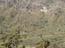
Other articles:
Locations:
Striped Mountain.
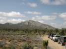
|
Striped Mountain to the south. | ||
|
Other articles:
|
Junction: CR 20739 | ||
|
Other articles:
|
Junction: Kessler Springs Road, north to US I-15 at Valley Wells, south to Cima. | ||
| If you have a question or a comment you may write to me at: tomas@schweich.com I sometimes post interesting questions in my FAQ, but I never disclose your full name or address. |
Date and time this article was prepared: 9/22/2024 4:38:38 PM |