Eastern Mojave Vegetation
Tom Schweich
|
Eastern Mojave Vegetation
| Black Butte Road |
|
Tom Schweich |

|
"Black Butte Road" doesn't exist. However, I am using this name for a loose conglomeration of unnamed roads from Old Spanish Trail Road to Sandy Valley Road. | |
|
Other articles:
|
Junction: Old Spanish Trail Road | |
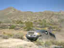
| Cross country | ||
|
Other articles:
|
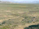
Small valley | |
| Lovell Wash Road | ||
|
Other articles:
|
Lovell Wash Crossing | |
|
Literature Cited:
Other articles:
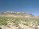
Locations: Black Butte. |
Black Butte is a 200 m high, northwest-trending ridge located at the center of the southernmost Pahrump Valley and is composed of ~1000 m of northeast-dipping sedimentary and volcanic strata (Guest, et al., 2007). The likely source of these sediments is Devil Peak, approximately 30 km to the south. The offset between these two locations across the Stateline Fault System, is one line of evidence for at least 30 km of dextral slip along the fault. | |
|
Other articles:
|
Junction: Sandy Valley Road | |
| If you have a question or a comment you may write to me at: tomas@schweich.com I sometimes post interesting questions in my FAQ, but I never disclose your full name or address. |
Date and time this article was prepared: 9/22/2024 4:46:58 PM |