
|
For the most part US Highway 91 has been replaced by US Interstate 15. There are two segments of US Highway remaining. A northern segment follows a route abandoned by I-15 from just south of Pocatello, Idaho, through Logan, Utah, and then into the Great Salt Lake basin, where I-15 is rejoined. The southern segment of US Highway 91 heads west from Saint George, Utah then turns south to Littlefield, Arizona, bypassing the route that I-15 now takes through the Virgin River Canyon.
|
|
|
Northern segment of US Highway 91 is below.
|
|
Other articles:
• Interstate 15:
Idaho Exit 36;
|
Junction: US Interstate 15, north to Pocatello, Idaho, or south to Salt Lake City, Utah.
The reason to take US Hwy 91 south rather than I-15 would be to view the spillway of Pleistocene Lake Bonneville into the Snake River drainage at Zenda and Red Rock Pass.
|
|
Literature Cited:
- Hart, William S., Jay Quade, David B. Madsen, Darrell S. Kaufman, and Charles G. Oviatt., 2004.
Locations:
Zenda.
|
Zenda
Location in southern Idaho, off US Highway 91.Zenda is given as the location of an alluvial dam that held the highest stand of Pleistocene Lake Bonneville for 500 to 1000 years before it eroded, creating the Bonneville Flood.
|
|
Other articles:
• Field Notes:
21 Oct 2017;
 View south to Red Rock Pass View south to Red Rock Pass
 Looking north towards Zenda (in the trees) Looking north towards Zenda (in the trees)
|
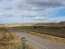
Stopped at a little hill between Zenda and Red Rock Pass.
|
|
Literature Cited:
- Hart, William S., Jay Quade, David B. Madsen, Darrell S. Kaufman, and Charles G. Oviatt., 2004.
Other articles:
• Field Notes:
21 Oct 2017;
Locations:
Red Rock Pass.
|
Red Rock Pass
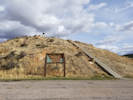
Hill with monument |

Interpretive Panel for Red Rock Pass |

Interpretive Panel for Red Rock Pass |

Memorial plaque to Captain Jefferson Hunt |
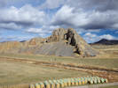
View from top of hill |
Bedrock threshold for the Provo shoreline of Pleistocene Lake Bonneville.
Red Rock Pass Geological Site
About 14,500 years ago, ancient Lake Bonneville overflowed at this site.
A dam of alluvial fans between Oxford Mountain to the west
and the Portneuf Range to the east
suddenly eroded releasing Lake Bonneville from the Great Basin
into the Snake River system.
The Peak flow was about one million cubic meters per second at the pass,
or about 500 times the maximum discharge on the Snake River at Idaho Falls, Idaho.
Ancient “bathtub ring” shorelines up to 1,000 feet above the valley
floor are readily visible in the Salt Lake Valley.
Evidence of the flood is visible thoughout southern Idaho with
areas of scoured bare bedrock (“scabland”)
and deposits of boulders (“melon gravel”) marking the flood path.
After about 11,000 years, Lake Bonneville receded to become the Great Salt Lake.
Highly saline and only 40 feet deep, it is but a shadow of
giant fresh-water Lake Bonneville.
Red Rock Pass is the geographic northern extremity of the Bonneville drainage
basin, and was also designated by the early Latter-day Saint leaders as
the northern edge of the proposed State of Deseret.
North of here, water flows to the Snake, Salmon, and Columbia rivers,
on the way to the Pacific Ocean, but south of here it flows into the Great Basin and the Great Salt Lake.
South of the monument in Red Rock Pass, the house-sized limestone blocks
were jostled during the breakout of the Bonneville flood.
The uneven topography northwest of the monument is a landslide which flowed
into Red Rock Pass after it was deepened about 400 feet during the flood.
Ancient cave formations are found in the flat-lying limestone of
Red Rock Butte immediately north of the monument.
|
Red Rock Pass
You are standing in the outlet of ancient Lake Bonneville.
A vast prehistoric inland sea,
of which Salt Lake is a modern remnant.
Covering over 20,000 square miles when it overflowed
here about 14,500 years ago,
its winding shoreline would have stretched from
here to New Orleans if it were straightened out.
This pass was deepened considerably when Lake Bonneville
began to slow into Snake River.
For a time, a torrent several times larger than
the Amazon was discharged here.
Finally, with a hotter, drier climate that slowly emerged about 8,000 years ago,
Lake Bonneville gradually disappeared.
|
No 119
Erected October 2, 1950
Captain Jefferson Hunt, Soldier, Pioneer, Churchman
Charles Jefferson Hunt served in the Mormon Battalion as
captain of Company “A” and as assistant executive officer, in
its historic march from Council Bluffs, Iowa to San Diego, California, 1846-47.
His service won the commendation of all who served with him.
Under appointment by President Brigham Young in 1851,
Captain Hunt was guide for the pioneers to San Bernardino, California.
His pioneering service included also Provo, Parowan,
and Huntsville (which bears hus name), in Utah, and Oxford, Idaho.
A convert to the church of Jesus Christ of Latter-Day Saints
he was loyal, obedient, and faithful to the end.
Erected by descendents of Captain Hunt and the
Utah Pioneer Trails and Landmarks Association.
|
|
|
|
Idaho Above.
Utah below.
|
|
Other articles:
• U. S. Hwy 89:
at W. 400 N.;
|
Intersection: W. 400 N., US Highway 89, northbound Highway 89 climbs northeast through Logan Canyon, and turns east toward Bear Lake.
To the south, US Highways 89 and 91 share a route over Sardine Summit,
|
|
Locations:
Logan.
|
Logan
W. 300 N.
|
|
Locations:
Logan.
|
Logan
|
|
|
East and West Center Street
|
|
|
Intersection: South Main Street, Utah Highway 165, Southern Cache Valley.
|
|
Other articles:
• U. S. Hwy 89:
at US 91S;
|
US Highways 89 and 91 share a route north over Sardine Summit to Logan.
Junction: US Highway 89, south to Salt Lake City, Utah, or north to Logan where the routes diverge.
|
|
Other articles:
• Interstate 15:
Utah Exit 364;
|
Brigham City
Junction: US Interstate 15, south to Salt Lake City, Utah, or north to Pocatello, Idaho.
|
|
|
The northern segment of US Highway 91 is found above.
The southern segment of US Highway 91 is found on the next page.
|
|
|
[Next Page]
Go to page: [A] [B]
|
|
If you have a question or a comment you may write to me at:
tomas@schweich.com
I sometimes post interesting questions in my FAQ, but I never disclose your full name or address.
|
[Home Page] [Site Map]
Date and time this article was prepared:
9/22/2024 4:48:37 PM
|
 U. S. Highways