Eastern Mojave Vegetation
Tom Schweich
|
Eastern Mojave Vegetation
| California Highway 178 |
|
Tom Schweich |

Topics in this Article: Shoshone |
(No Preface) | ||||||
|
Other articles:
|
BakersfieldJunction: California Highway 58, California Highway 99 | ||||||
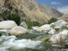
 Entrance to Kern Canyon near Bakersfield Entrance to Kern Canyon near Bakersfield
|
Entrance to Kern Canyon. | ||||||
Historical marker beside highway:
| |||||||
|
Other articles:
Locations:
Kern River.
|
Lower Kern Canyon | ||||||
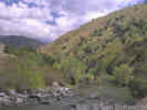 Lower Kern Canyon Lower Kern Canyon
|
Lower Kern Canyon | ||||||
|
Other articles:
|
Lake IsabellaJunction: California Highway 155 | ||||||
|
Other articles:
Locations: Isabella Lake. |
Isabella Lake | ||||||
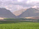
 South Fork Valley South Fork Valley
|
|||||||
|
Locations: Onyx. |
OnyxSmall settlement along CA Highway 178. | ||||||
|
Other articles:
|
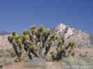
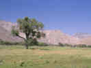
Joshua Trees (Yucca brevifolia) are found from Onyx to Walker Pass, a distance of about 12 miles. There is some thought that Native Americans may have transported seeds into South Fork Valley from the Mojave Desert. | ||||||
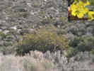 Fremontia (Fremontodendron californicum) in South Fork Valley. Fremontia (Fremontodendron californicum) in South Fork Valley.
|
East of Onyx was a north-facing hillside with many Fremontia (Fremontodendron californicum) in bloom. | ||||||
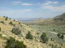
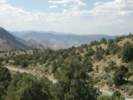 View northwest from Walker Pass. View northwest from Walker Pass.
|
View northwest from Walker Pass. I think the flat topography in the distance would be identified as the Kern Plateau. | ||||||
|
Other articles:
Locations:
Walker Pass.
|
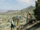
Walker PassHistorical plaque at Walker Pass reads as follows:
| ||||||
|
Other articles:
Locations:
Walker Pass.
|
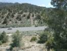
View south across Walker Pass. Sagebrush on the open slopes merges into the Pinyons on the upper slopes. | ||||||
|
Other articles:
|
Steve inspects the weather station in Walker Pass. There is also a Walker Pass RAWS a few miles west. | ||||||
|
Other articles:
Locations:
Walker Pass.
|
View east from Walker Pass. The vegetation here is Pinyons, Juniper, Big Sagebrush, and Bitterbrush. | ||||||
|
Locations: Freeman Canyon. |
Freeman Canyon | ||||||
|
Other articles:
Species Lists: Salvia dorrii |
| ||||||
|
Other articles:
Locations:
Robber's Roost.
|
Soldier Wells. Don't take this road to Robber's Roost. It's closed at the other end. | ||||||
|
Other articles:
|
Junction: California Highway 14 | ||||||
|
Other articles:
|
Junction: California Highway 14 | ||||||
|
Locations: Inyokern. |
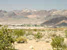
InyokernInyokern | ||||||
|
Other articles:
|
Junction:
| ||||||
|
Other articles:
|
Junction:
| ||||||
|
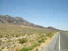
Locations: Salt Wells Valley. |
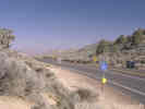
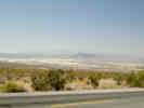
Salt Wells ValleySalt Wells Valley is north of CA Highway 178. Carl Purpus may have collected here in 1898. He was definitely in the area, on his way from Indian Wells Valley to the Argus Range, when he mentions stopping at Salt Wells. Annie Alexander and Louise Kellogg may have also collected here in 1940, when they mention collecting in Salt Canyon, and Salt Wells Canyon. | ||||||
|
Locations: Poison Canyon. |
Poison Canyon | ||||||
|
Other articles:
|
Junction:
| ||||||
|
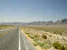
This is the missing segment of California Highway 178. The western segment, above this break, runs from Bakersfield to the intersection with Trona Road, south of Trona. The eastern segment, below this break, runs from Death Valley to Shoshone. Apparently, Highway 178 was originally planned to pass through Wingate Pass, but this portion of the route was never constructed. | |||||||
|
Other articles:
|
Junctions:
| ||||||
|
Locations: Jubilee Pass. |
Jubilee Pass | ||||||
|
Literature Cited:
Locations: Salsberry Pass. |
Salsberry PassNear Salsberry Pass are several research sites used by Forseth and Ehleringer (1982) in measuring sun-tracking leaf movements in relation to leaf conductance and water potential in Malvastrum rotundifolium and Lupinus arizonicus. | ||||||
|
Literature Cited:
Other articles:
|
In one of the early studies on desert varnish, Engel and Sharp (1958) performed wet chemical analyses on varnish, the underlying weathered rind, and fresh rock from ten locations in southeast California. One of the locations was at the north end of Sheephead Mountain in the Ibex Hills 150 yards southeast of the highway through Salsberry Pass. Engel and Sharp found that (1) varnish on stones seated in soil or colluvium is derived largely from that material, (2) varnish on large bedrock esposures come from weathered parts of the rock, (3) air-borne material is probably a minor contributor. | ||||||
|
Other articles:
|
Junction: Furnace Creek Wash Road | ||||||
|
Other articles:
|
Junction:
| ||||||
|
|
Shoshone | ||||||
|
Other articles:
|
Junction: CA Hwy 127, south to Baker. | ||||||
 Dugout in "Castles of Clay" Dugout in "Castles of Clay"
|
"Castles of Clay" | ||||||
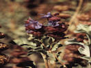
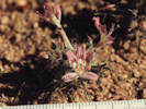
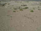 Phacelia calthifolia Brand growing in pattern aligned with subsurface cracks. Phacelia calthifolia Brand growing in pattern aligned with subsurface cracks.
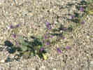 Phacelia calthifolia Brand near Shoshone. Phacelia calthifolia Brand near Shoshone.
|
|||||||
|
Other articles:
|
|||||||
|
Other articles:
|
|||||||
|
Other articles:
Locations: Resting Spring Range. |
Resting Spring Range | ||||||
|
Other articles:
Locations:
Chicago Valley.
|
|||||||
|
Other articles:
|
Chicago Valley | ||||||
|
Other articles:
Locations:
Chicago Valley.
|
|||||||
|
|
Stewart Valley | ||||||
|
Other articles:
|
Junction: Nevada Highway 372 | ||||||
| If you have a question or a comment you may write to me at: tomas@schweich.com I sometimes post interesting questions in my FAQ, but I never disclose your full name or address. |
Date and time this article was prepared: 7/13/2024 8:01:28 AM |