
Eastern Mojave Vegetation
By Tom Schweich
|
Eastern Mojave Vegetation | Images -- Geography - Santa Clara County |
|
By Tom Schweich |
|

Unclassified Geography - Idaho Geography - Park County, CO Geography - Summit County, CO Geography - Arizona Geography - British Columbia Geography - California Geography - California's Colorado Desert Alaska Geography - Mono Lake Basin, California Geography - Mono County, California Geography - San Luis Obispo County, California Geography - Marin County, California Geography - Santa Clara County Alameda Garden Geography - Central Mojave Geography - New Mexico Geography - Eastern Mojave Geography - Northern Mojave Geography - Colorado Geography - Alamosa County, CO Geography - Boulder County, CO Geography - Clear Creek County, CO Geography - Chaffee County, CO Geography - Douglas County, CO Geography - Gilpin County, CO Geography - Golden, Colorado Geography - Weld County, CO Geography - Hinsdale County, CO Geography - Jefferson County, CO Geography - North Table Mountain, Jefferson Cty, CO Geography - Lake County, CO Geography - Larimer County, CO Geography - Nevada Geography - Oregon Geography - South Dakota Geography - Utah Geography - Virginia Geography - Washington Geography - Wyoming Spain - Andalucia Spain - Castilla y Leon Spain - Castilla-La Mancha Spain - Extremadura Spain - Galicia Spain - Madrid Portugal Geology Economic Geology Climatology Botany Salvia dorrii Frasera albomarginata Species Species - Polygonaceae Species - Brassicaceae Species - Brassicaceae, Physaria vitulifera Species - Rosaceae Species - Fabaceae Species - Onagraceae Species - Polemoniaceae Species - Boraginaceae Species - Plantaginaceae Species - Asteraceae Species - Poaceae Zoology Ecology Archeology Customer Satisfaction General Arizona California Kansas Missouri Nebraska New York Christmas 2002 Family Photos Family Documents Family Photos 2003 Art of Lydia Schweich Portraits Railroad Geography - Germany |
Images are organized by the topics listed at left. Click on a topic name to see images with that topic. Would you like to use these photographs in your school term paper or report? License is hereby granted for non-commercial use of the images contained herein provided that the images are reproduced with the copyright notice intact. This means that we give you our permission to use the photographs and information you find here in your school term papers and reports. You may resize the photograph to fit your needs, but you may not remove the copyright. Your term paper should note that the photographs are reproduced with permission and it should have a reference to this web site, such as: "Photograph �1999 Tom Schweich. Used by permission, http://www.schweich.com" If you have a comment or a question about a photograph you may write to me at tomas@schweich.com I will answer you as soon as I can. I sometimes post interesting questions in my FAQ, but I will not disclose your full name or address.
| Ulistac Natural Area
| 
Near the northeast corner. | Photographed 20 October 2013
Location records that use this photograph:
Article records that use this photograph:
images/IMGQ0070sm.jpg
| 
Orientation sign. | Photographed 20 October 2013.
Location records that use this photograph:
Article records that use this photograph:
images/IMGQ0058esm.jpg
| 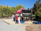
South Entrance of Ulistac Natural Area | Photographed 20 October 2013
Location records that use this photograph:
Article records that use this photograph:
images/IMGQ0056sm.jpg
| 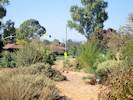
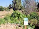
Planted area in Ulistac Natural Area | Photographed 20 October 2013
Location records that use this photograph:
Article records that use this photograph:
images/IMGQ0060sm.jpg
| 
Along a path. | Photographed 20 October 2013
Location records that use this photograph:
Article records that use this photograph:
images/IMGQ0068sm.jpg
| 
Along a path. | Photographed 20 October 2013
Location records that use this photograph:
Article records that use this photograph:
images/IMGQ0069sm.jpg
| 
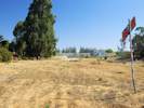
The main path. | Photographed 20 October 2013
Location records that use this photograph:
Article records that use this photograph:
images/IMGQ0082sm.jpg
| 
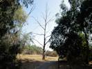
A portion of the natural area is crossed by a pipeline and an aqueduct. | Photographed 20 October 2013
Location records that use this photograph:
Article records that use this photograph:
images/IMGQ0064sm.jpg
| 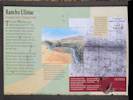
Interpretive sign at Ulistac Natural Area. | Photographed 20 October 2013.
Location records that use this photograph:
Article records that use this photograph:
images/IMGQ0065sm.jpg
| 
Vernal pond. | Photographed 20 October 2013. Construction of the pond was an Eagle Scout project by Joey Brett in 2012.
Location records that use this photograph:
Article records that use this photograph:
images/IMGQ0062sm.jpg
|
| Date and time this article was prepared: 4/21/2025 8:34:04 PM | ||||||||