
Topics in this Article:
1800s
1900s
1910s
1920s
1930s
1940s
1950s
1960s
1970s
1980s
1990
1991
1992
1993
1995
1996
1997
1998
1999
2000
2001
2002
2003
2004
2005
2006
2007
2008
2008 Tour de Swertia albomarginata
Mono Lake, August 2008
2009
2010
2011
2012
2013
2014
2015
2016
2017
2018
2019
2020
2021
2022
2023
2024
2025
Contents
Literature Cited
|
|
When I first read the field notes of Annie Alexander and Louise Kellogg, I was fascinated by the descriptions they wrote about the places they went and the plants and animals they found there. By publishing my field notes on the Internet I hope to follow a little bit in their tradition.
|
|
|
|
2025
|
|
|
|
January, 2025
|
|
Other articles:
• Golden Checklist Flora:
Cottonwood Open Space;
• Welch Ditch:
near boundary;
Locations:
Cottonwood Natural Area.
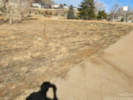
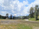
 View to southeast from Welch Ditch across Cottonwood Natural Area. View to southeast from Welch Ditch across Cottonwood Natural Area.
|
|
Thursday, 2 January 2025
Walked the Cottonwood Natural Area with several residents and members of Stewards of Golden Open Space.

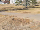
View to the north across Cottonwood Natural Area. |

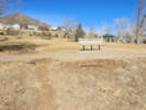
View to the southeast, high school at left, surge pond in center, Lookout Mountain Youth Services at right. |

Berries of a Lycium, either L. barbarum or L. chinense, in Kinney Run. |

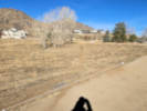
View to the south across the Cottonwood Natural Area. |

Golden High School as seen from the end of the social trail through Cottonwood Natural Area. |
|
|
Literature Cited:
- Sovell, John R., and Susan S. Panjabi, 2021.
Other articles:
• Kinney Run Trail:
at end;
near bridge;
n. end of o. s.;
along rck wall;
at intersection;
Locations:
Kinney Run South.
|
|
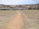
Friday, 3 January 2025
Kinney Run South

Continuation of Kinney Run Trail at the end of Tripp Drive. |

Just the north side of the bridge. |

Along the trail. |

Coarse sediments over fine. |

Winter scene in Kinney Run South. |

Discarded desk chair in Kinney Run South. |

Discarded bicycle in Kinney Run South open space. |

Method of connecting a barbed-sire fence to the cliff. |

View north through Golden Valley. |

View south through Kinney Run South. |
|
|
Other articles:
• Magpie Gulch Trail:
at mtn bike trl;
Locations:
New Loveland Mine Park.
 The first few bicycle tracks visible on Monday, 3 February 2025 The first few bicycle tracks visible on Monday, 3 February 2025
|
|
Monday, 3 February 2025
|
|
Other articles:
• Magpie Gulch Trail:
at mtn bike trl;
• Field Notes:
19 Dec 2024;
23 Mar 2025;
Locations:
New Loveland Mine Park.
 Bicycle tracks on Wednesday, 5 February 2025 Bicycle tracks on Wednesday, 5 February 2025
|
|
Wednesday, 5 February 2025
I made Fix-It report #32913
Planted the following seeds:
- Asclepias incarnata
- Arnica fugens
- Helianthus pauciflora subrhomboidea
- Senecio integerrimus
- Erysimum capitatum
- Astragalus drummondii
- Monarda pectinata
- Mentzelia muda
- Leptodactylon pungens
- Ipomopsis aggregata
- Eriogonum effusum
- Sphaeralcea coccinea
- Mirabilis multiflora
- Penstemon secundiflorus
- Penstemon virens
- Penstemon virgatus
- Achnatherum hymenoides
- Sporobolus cryptandrus
|
|
|
|
Thursday, 6 February 2025
Fix-It report 32943. Someone has been riding their mountain bikes through the park and surrounding open space (creating new "social trails"). I think some simple signage, filling the hole, and blocking their current paths with simple "do not enter" held by a couple of wooden stakes tape would hopefully discourage further destruction of our park and open space.
|
|
Other articles:
• Magpie Gulch Trail:
at mtn bike trl;
at mtn bike trl;
Locations:
New Loveland Mine Park.
 Digging and piling up of dirt. Digging and piling up of dirt.
|
|
Friday, 7 February 2025
Mountain bike jump and trails in New Loveland Mine Park.
Fix-It Report #32971.
Someone has been riding their mountain bikes through the park and surrounding open space (creating new "social trails"). I think some simple signage, filling the hole, and blocking their current paths with simple "do not enter" held by a couple of wooden stakes tape would hopefully discourage further destruction of our park and open space.
The response on Fix-It was:
Thank you for your report. Two previous reports about this trail were already submitted to FixIt! so staff are aware. Staff will be adding signage to that entire area identifying it a s sensitive area and asking to people to stay out. The signs will be located in way that would deter use of this specific trail. It is likely that additional steps may be required but are working to get the signs in place ASAP. Specific to the jump, this afternoon staff worked to remove or replace the material. ~ Parks Staff
Downhill runout from mountain bike jump. |
Mountain bike jump. |

Mountain bike trails in New Loveland Mine Park. |
|
|
Other articles:
• Field Notes:
19 Dec 2024;
5 Feb 2025;
Locations:
New Loveland Mine Park.
 Backhoe tracks through the natural area of New Loveland Mine Park. Backhoe tracks through the natural area of New Loveland Mine Park.
|
|
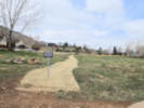
Sunday, 23 March 2025
Filed Fix-It Report #33832
On Friday, March 21, 2025, a contractor installed the footings for public art in New Loveland Mine Park. While on my way to the Community Center, I observed them setting up, and then working on the footing for the northerly art piece, and observed them again later in the morning digging out the hole for the footing. It was pretty clear they had run their little backhoe down the concrete trail. Unfortunately, after digging out the southerly footing, the contractor used the social trail to return their backhoe to the parking lot. This is evident in the attached photo as there are two new tracks that span the social trail. The damaged width in the natural area of New Loveland Mine Park is now at least 8 feet wide. This is not the first time a piece of equipment has been driven up the social trail. See Fix-It Report #32059, in which one of our own Stormwater guys drove a Skid-Steer up the the same trail. I had understood in your response to Fix-It reports #32913, #32943, and #32971, that there would be some signage placed around the natural area that "identifying it as sensitive area and asking to people to stay out. The signs will be located in way that would deter use of this specific trail. It is likely that additional steps may be required but are working to get the signs in place ASAP." So far there is no signage, and no other obvious attempt to protect the natural area from unnecessary damage. Since the city's contractors dug a pretty big hole and placed forms around it, I assume that concrete will be poured into the holes. Please direct the contractor not to drive a cement truck through the natural area.
.
|
|
Other articles:
• Magpie Gulch Trail:
social train down;
Locations:
New Loveland Mine Park.
 Rehabilitation of the social trail through New Loveland Mine Park. Rehabilitation of the social trail through New Loveland Mine Park.
|
|
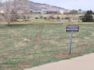
Saturday, 29 March 2025
Walk through New Loveland Mine Park.

Signage at the mountain bike trail. |
|
|
Other articles:
• Magpie Gulch Trail:
at mtn bike trl;
social trail Cyn Vw Dr;
Locations:
New Loveland Mine Park.
 Signage at south end of closed social trail. Signage at south end of closed social trail.
|
|
Sunday, 30 March 2025
Signage at lower end of mountain bike trail. |
|
|
Other articles:
• Interstate 70:
132610;
Locations:
Green River.
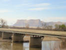 View from Tamarisk Restaurant in Green River. View from Tamarisk Restaurant in Green River.
|
|
Monday, 31 March 2025
Golden, CO, to Richfield, UT
|
|
Other articles:
• Interstate 70:
Richfield;
Locations:
Richfield.
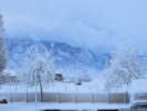 Five inches of snow overnight in Richfield, Utah. Five inches of snow overnight in Richfield, Utah.
|
|
Tuesday, 1 April 2025
Richfield, UT, to Pahrump, NV
|
|
Other articles:
• U. S. Highway 91:
n. slope;
404700;
at Mojave Desert Joshua Tree Rd;
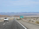
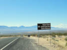 View south on Old Highway 91 to Littlefield, Arizona. View south on Old Highway 91 to Littlefield, Arizona.
 View north to the Red Mountains and then the Pine Valley Mountains. View north to the Red Mountains and then the Pine Valley Mountains.
|
|
Old Highway 91
View south towards the pass through the Beaver Dam Mountains. |
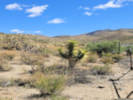
Joshua tree along Old Highway 91. |
|
|
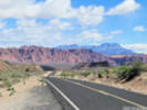
Other articles:
• Scenic Loop Drive:
at visitor ctr;
at Calico I;
along road;
at o'look;
Locations:
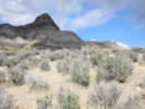
Red Rock Canyon National Conservation Area.
 View from the Visitor Center. View from the Visitor Center.
|
|
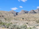
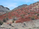
Red Rock Canyon

Cross-bedded sandstone at Calico I. |
Blackbrush along the road. |

Calico Basin seen from High Point Overlook. |
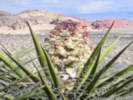
“Mohave Yucca” — Yucca schidigera K. E. Ortiges in bloom at the High Point Overlook. |

View south from High Point Overlook |

Looking towards Red Rock Canyon from the High Point Overlook. |
|
|
Other articles:
• Bell Vista Road:
somewhere;
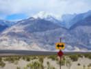
 Red stems from last year's Eriogonum inflatum. Red stems from last year's Eriogonum inflatum.
|
|
Wednesday, 2 April 2025
Pahrump, NV, to Bakersfield, CA. Just out of Pahrump we drove west and through some small unnamed hills.
|
|
Other articles:
• California Highway 127:
at Death Valley Junction;
• CA Hwy 190:
Towne Pass;
at sea level;
at Zabriskie Point;
at Gower Gulch;
• Dantes View Road:
near top;
at Dantes View;
• Furnace Creek Wash Road:
at Billie Mine;
12000;
• Panamint Valley Road:
near CA 190;
• Trona Wildrose Road:
at Panamint Valley Road;
at Pass;
Locations:
Billie Mine.
Dante's View.
Death Valley.
Death Valley Junction.
Panamint Valley.
Ryan.
Towne Pass.
Zabriskie Point.
 The Amargosa Opera House at Death Valley Junction (2025). The Amargosa Opera House at Death Valley Junction (2025).
|
|
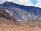
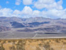
Death Valley

Roads in Death Valley Junction. |
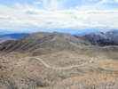
Last part of the road to Dante's View. |

Floor of Death Valley from Dante's View (2025). |

Panamint Mountains across Death Valley (2025). |

Billie Mine across Furnace Creek Wash. |
Ryan. |
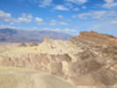
Manley Beacon from Zabriskie Point. |
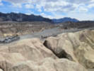
Diversion of Furnace Creek Wash into Gower Gulch. |

Sea Level. |

Tucki Mountain from the Sea Level sign. |
View south towards Furnace Creek from the Sea Level sign. |
Towne Pass, elevation 4956 feet. |
Landscape beside the road at Towne Pass. |
Looking back across Panamint Valley in the direction of Towne Pass. |
Telescope Peak from the floor of Panamint Valley. |
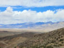
Panamint Valley and Panamint Range (2025). |
|
|
Other articles:
• Trona Road:
Trona;
Locations:
Trona.
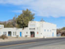
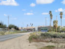
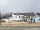 Chemical plant in Trona. Chemical plant in Trona.
|
|
Trona

Chemical plant in Trona. |
|
|
Other articles:
• CA Hwy 178:
just below Walker Pass;
Locations:
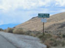
Walker Pass.
 Leptosyne bigelovii (A. Gray) A. Gray “Bigelow's tickseed” beside Highway 178. Leptosyne bigelovii (A. Gray) A. Gray “Bigelow's tickseed” beside Highway 178.
|
|
Walker Pass
|
|
|
|
Woolgrowers Restaurant
|
|
|
|
Thursday, 3 April 2025
Bakersfield, CA, to San Luis Obispo, CA
|
|
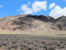
Other articles:
• California Highway 33:
s. edge McKittrick;
out there somewhere;
Locations:
McKittrick.
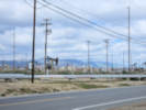 Oil fields between McKittrick and Taft. Oil fields between McKittrick and Taft.
|
|
Lost between McKittrick and Taft.
South side of McKittrick. |
|
|
|
|
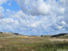
Carrizo Plain
|
|
Other articles:
• Shell Creek Road:
n. of Shell Ck;
at Shell Creek tree;
along road;
Locations:
Shell Creek.
 The oak tree at Shell Creek, April 2025. The oak tree at Shell Creek, April 2025.
|
|
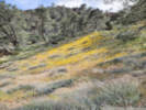
Shell Creek
North on Shell Creek Road, April 2025. |
South on Shell Creek Road, April 2025. |
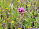
Castilleja exserta (A.Heller) T.I.Chuang & Heckard “Purple Owl's-clover” along Shell Creek Road. |

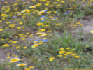
A field of Goldfields. |

North on Shell Creek Road. |
Baby Blue Eyes, Goldfields, and Tidy-Tips. |
|
|
Other articles:
• Avila Beach Drive:
at Avila Beach;
Locations:
Port San Luis.
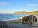
San Luis Obispo Bay.
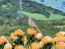 California Thrasher. California Thrasher.
|
|
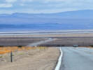
Friday, 4 April 2025
San Luis Obispo to Avila Beach, CA

Sea otter and baby by the Port San Luis Pier. |
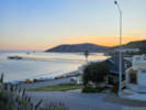
Sunset at San Luis Obispo Bay. |
San Luis Obispo Bay in the morning. |
|
|
Other articles:
• Halcyon Road:
15000;
Locations:
Arroyo Grande Cemetery.
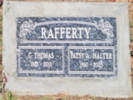 Headstone for Pat and Tom Rafferty. Headstone for Pat and Tom Rafferty.
|
|
Saturday, 5 April 2025
Avila Beach, CA
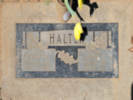
Headstone for Grammy & Grampy Halter |
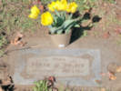
Headstone for Frank W. Halter |

Headstone for Beverley Jane Halter. |
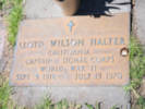
Headstone for Lloyd Wilson Halter. |
|
|
Other articles:
• Bishop Street:
at Terrace Hill;
Locations:
San Luis Obispo.
Terrace Hill.
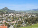 View west of San Luis Obispo from Terrace Hill. View west of San Luis Obispo from Terrace Hill.
|
|
Sunday, 6 April 2025
Avila Beach, San Luis Obispo, and Cambria, CA
Site of the former roundhouse at San Luis Obispo. |
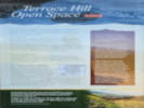
Interpretive panel for Terrace Hill. |

View northeast from Terrace Hill. |
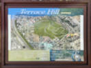
Trail map for Terrace Hill. |

City of San Luis Obispo, Open Space Rules. |
|
|
Other articles:
• Santa Barbara Avenue:
at rr mus.;
 Pacific Coast Railway Boxcar #1200 Group Pacific Coast Railway Boxcar #1200 Group
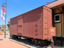 Pacific Coast Railway boxcar. Pacific Coast Railway boxcar.
|
|
San Luis Obispo Railroad Museum
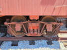
Arch bar trucks of the older boxcar. |
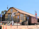
California, San Luis Obispo County, California, San Luis Obispo County, San Luis Obispo Railroad Museum |
|
|
Other articles:
• Windsor Boulevard:
at Fiscalini Rch Pres;
Locations:
Fiscalini Ranch Preserve.
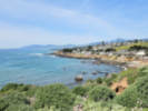 View north along the cliffs from Fiscalini Ranch Preserve. View north along the cliffs from Fiscalini Ranch Preserve.
|
|
Fiscalini Ranch Preserve Bluff Trail
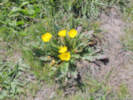
Taraxia ovata (Nutt. ex Torr. & A. Gray) Small in the Fiscalini Ranch Preserve. |
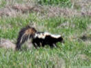
Skunk doing some daytime hunting. |
|
|
Other articles:
• Interstate 15:
at Zzyzx Road;
Locations:
Zzyzx.
 The Zzyzx Road exit from Interstate 15. The Zzyzx Road exit from Interstate 15.
|
|
Monday, 7 April 2025
Avila Beach, CA, to Las Vegas, NV
|
|
Other articles:
• Interstate 70:
at rest area;
 View southeast across Utahraptor Ridge to the La Sal Mountains. View southeast across Utahraptor Ridge to the La Sal Mountains.
|
|
Tuesday, 8 April 2025
Las Vegas, NV, to Grand Junction, CO
|
|
|
|
Wednesday, 9 April 2025
Grand Junction, CO, to Golden, CO
|
|
|
|
Saturday, 12 April 2025
New Loveland Mine Park
|
|
|
|
[Previous Page]
[Next Page]
Go to page: [1800s] [1900s] [1910s] [1920s] [1930s] [1940s] [1950s] [1960s] [1970s] [1980s] [1990] [1991] [1992] [1993] [1994] [1995] [1996] [1997] [1998] [1999] [2000] [2001] [2002] [2003] [2004] [2005] [2006] [2007] [2008] [2009] [2010] [2011] [2012] [2013] [2014] [2015] [2016] [2017] [2018] [2019] [2020] [2021] [2022] [2023] [2024] [2025] [A]
|
|
If you have a question or a comment you may write to me at:
tomas@schweich.com
I sometimes post interesting questions in my FAQ, but I never disclose your full name or address.
|
[Home Page] [Site Map]
Date and time this article was prepared:
4/21/2025 8:27:20 PM
|
 Eastern Mojave Vegetation