
Eastern Mojave Vegetation
By Tom Schweich
|
Eastern Mojave Vegetation | Images -- Geography - Marin County, California |
|
By Tom Schweich |
|

Unclassified Geography - Idaho Geography - Park County, CO Geography - Summit County, CO Geography - Arizona Geography - British Columbia Geography - California Geography - California's Colorado Desert Alaska Geography - Mono Lake Basin, California Geography - Mono County, California Geography - San Luis Obispo County, California Geography - Marin County, California Geography - Santa Clara County Alameda Garden Geography - Central Mojave Geography - New Mexico Geography - Eastern Mojave Geography - Northern Mojave Geography - Colorado Geography - Alamosa County, CO Geography - Boulder County, CO Geography - Clear Creek County, CO Geography - Chaffee County, CO Geography - Douglas County, CO Geography - Gilpin County, CO Geography - Golden, Colorado Geography - Weld County, CO Geography - Hinsdale County, CO Geography - Jefferson County, CO Geography - North Table Mountain, Jefferson Cty, CO Geography - Lake County, CO Geography - Larimer County, CO Geography - Nevada Geography - Oregon Geography - Utah Geography - Virginia Geography - Washington Geography - Wyoming Spain - Andalucia Spain - Castilla y Leon Spain - Castilla-La Mancha Spain - Extremadura Spain - Galicia Spain - Madrid Portugal Geology Economic Geology Climatology Botany Salvia dorrii Frasera albomarginata Species Species - Polygonaceae Species - Brassicaceae Species - Brassicaceae, Physaria vitulifera Species - Rosaceae Species - Fabaceae Species - Onagraceae Species - Polemoniaceae Species - Boraginaceae Species - Plantaginaceae Species - Asteraceae Species - Poaceae Zoology Ecology Archeology Customer Satisfaction General Arizona California Kansas Missouri Nebraska New York Christmas 2002 Family Photos Family Documents Family Photos 2003 Art of Lydia Schweich Portraits Railroad Geography - Germany |
Images are organized by the topics listed at left. Click on a topic name to see images with that topic. Would you like to use these photographs in your school term paper or report? License is hereby granted for non-commercial use of the images contained herein provided that the images are reproduced with the copyright notice intact. This means that we give you our permission to use the photographs and information you find here in your school term papers and reports. You may resize the photograph to fit your needs, but you may not remove the copyright. Your term paper should note that the photographs are reproduced with permission and it should have a reference to this web site, such as: "Photograph �1999 Tom Schweich. Used by permission, http://www.schweich.com" If you have a comment or a question about a photograph you may write to me at tas4@schweich.com I will answer you as soon as I can. I sometimes post interesting questions in my FAQ, but I will not disclose your full name or address.
| Point Reyes National Seashore
| 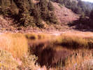
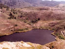
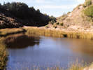
Crystal Lake. | Photographed in December 1979, scanned from a slide in 2023.
Location records that use this photograph:
Article records that use this photograph:
images/1979-12-1-24-img446sm.jpg
| 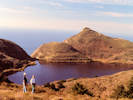
Cheryl and Matt at Pelican Lake. | Photographed in December 1979, scanned from a slide in 2023.
Location records that use this photograph:
Article records that use this photograph:
images/1979-12-1-13-img435sm.jpg
| 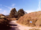
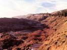
Trail Junction at Lake Ranch. | Photographed in December 1979, scanned from a slide in 2023.
Location records that use this photograph:
Article records that use this photograph:
images/1979-12-1-29-img439sm.jpg
| 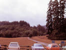
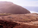
Bear Valley Trailhead. | Photographed in October 1979, scanned from a slide in 2023.
Article records that use this photograph:
images/1979-10-2-2-img422sm.jpg
| 
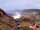
Headscarp at Crystal Lake. | Photographed in December 1979, scanned from a slide in 2023.
Location records that use this photograph:
Article records that use this photograph:
images/1979-12-1-23-img444sm.jpg
| 
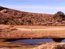
Pelican Lake. | Photographed in October 1979, scanned from a slide in 2023.
Location records that use this photograph:
Article records that use this photograph:
images/1979-10-3-5-img434sm.jpg
| 
Wildcat Camp. | Photographed in October 1979, scanned from a slide in 2023.
Location records that use this photograph:
Article records that use this photograph:
images/1979-10-1-2-img424sm.jpg
| 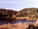
Bass Lake. | Photographed in December 1979, scanned from a slide in 2023.
Location records that use this photograph:
Article records that use this photograph:
images/1979-12-1-8-img437sm.jpg
| 
Crystal Lake. | Photographed in December 1979, scanned from a slide in 2023.
Location records that use this photograph:
Article records that use this photograph:
images/1979-12-1-22-img445sm.jpg
| 
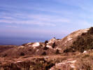
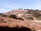
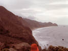
Coast Trail, Millers Point, and Point Resistance from above; looking north. | Photographed in October 1979, scanned from a slide in 2023.
Location records that use this photograph:
Article records that use this photograph:
images/1979-10-2-15-img432sm.jpg
| 
Head scarp near (above) Lake Ranch. | Photographed in December 1979, scanned from a slide in 2023.
Article records that use this photograph:
images/1979-12-1-14-img449sm.jpg
| 
Pressure ridges between Pelican and Crystal Lakes. | Photographed in December 1979, scanned from a slide in 2023.
Location records that use this photograph:
Article records that use this photograph:
images/1979-12-1-11-img440sm.jpg
| 
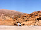
Cheryl and Matt at the Palomarin Slide, provides access to the beach. | Photographed in December 1979, scanned from a slide in 2023.
Location records that use this photograph:
Article records that use this photograph:
images/1979-12-2-14-img442sm.jpg
| 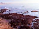
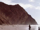
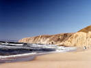
Palomarin Beach. | Photographed in December 1979, scanned from a slide in 2023.
Location records that use this photograph:
Article records that use this photograph:
images/1979-12-2-12-img441sm.jpg
| 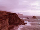
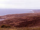
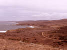
Millers Point and Double Point in the distance. | Photographed in October 1979, scanned from a slide in 2023.
Location records that use this photograph:
Article records that use this photograph:
images/1979-10-2-6-img421sm.jpg
| 
Headscarp where the Coast Trail crosses Alamere Cree. | Photographed in December 1979, scanned from a slide in 2023.
Location records that use this photograph:
Article records that use this photograph:
images/1979-12-1-27-img443sm.jpg
| 
Eating lunch behind a pressure ridge at North Double Point. | Photographed in October 1979, scanned from a slide in 2023. From left: Ed Kreps, unknown, Matt, Duncan Lloyd, unknown, Peter Slapar.
Location records that use this photograph:
Article records that use this photograph:
images/1979-10-3-4-img433sm.jpg
| 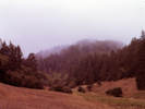
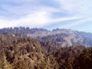
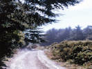
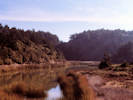
Divide Meadow. | Photographed in October 1979, scanned from a slide in 2023.
Location records that use this photograph:
Article records that use this photograph:
images/1979-10-2-4-img420sm.jpg
| 
North Double Point. | Photographed in October 1979, scanned from a slide in 2023.
images/1979-10-3-11-img431sm.jpg
| 
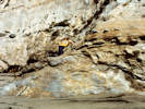
Clastic dike on Wildcat beach. | Photographed in October 1979, scanned from a slide in 2023.
Location records that use this photograph:
Article records that use this photograph:
Images/1979-10-3-18-img419sm.jpg
| 
Palomarin Beach, looking south towards Bolinas. | Photographed in December 1979, scanned from a slide in 2023.
Location records that use this photograph:
Article records that use this photograph:
images/1979-12-1-33-img438sm.jpg
| 
Head scarp above Crystal Lake. | Photographed in December 1979, scanned from a slide in 2023.
Location records that use this photograph:
Article records that use this photograph:
images/1979-12-1-18-img448sm.jpg
| 
Cheryl and Matt at Lake Ranch. | Photographed in December 1979, scanned from a slide in 2023.
Location records that use this photograph:
Article records that use this photograph:
images/1979-12-1-6-img436sm.jpg
| 
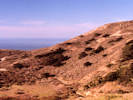
Hiking along Wildcat Loop above Glen Camp. | Photographed in October 1979, scanned from a slide in 2023.
Location records that use this photograph:
Article records that use this photograph:
images/1979-10-1-5-img426sm.jpg
| 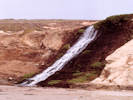
Alamere Falls. | Photographed in October 1979, scanned from a slide in 2023.
Location records that use this photograph:
Article records that use this photograph:
images/1979-10-3-9-img430sm.jpg
| 
Leaving Millers Point. | Photographed in October 1979, scanned from a slide in 2023. Wildcat Beach and Camp is in the middleground and Double Point is in distance.
Location records that use this photograph:
Article records that use this photograph:
images/1979-10-2-14-img423sm.jpg
| 
Matt on granite overlain by Francisco Formation. | Photographed in December 1980, scanned from a slide in 2023.
Location records that use this photograph:
Article records that use this photograph:
images/1980-12-img453sm.jpg
| 
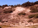
Sand dune deposits at Kehoe Beach. | Photographed in December 1980, scanned from a slide in 2023.
Location records that use this photograph:
Article records that use this photograph:
images/1980-12-img451sm.jpg
| 
Crystal Lake. | Photographed in December 1979, scanned from a slide in 2023.
Location records that use this photograph:
Article records that use this photograph:
images/1979-12-1-26-img447sm.jpg
| 
Kehoe Beach, looking north. | Photographed in December 1980, scanned from a slide in 2023.
Location records that use this photograph:
Article records that use this photograph:
images/1980-12-img450sm.jpg
| 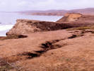
Marine terrace at Millers Point with 6 foot deep tension crack. | Photographed in October 1979, scanned from a slide in 2023.
Location records that use this photograph:
Article records that use this photograph:
images/1979-10-2-12-img429sm.jpg
| 
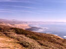
Looking north from Millers Point; Coast Trail and marine terraces. | Photographed in October 1979, scanned from a slide in 2023.
Location records that use this photograph:
Article records that use this photograph:
images/1979-10-2-13-img428sm.jpg
| 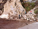
Mud and rock washed onto the beach by rain. | Photographed in October 1979, scanned from a slide in 2023. From left: Shim Farrell (?), Matt Schweich, Duncan Lloyd(?), and Peter Slapar.
Location records that use this photograph:
Article records that use this photograph:
images/1979-10-3-22-img425sm.jpg
|
| Date and time this article was prepared: 4/27/2024 3:34:54 PM | |