
Eastern Mojave Vegetation
By Tom Schweich
|
Eastern Mojave Vegetation | Images -- Economic Geology |
|
By Tom Schweich |
|

Unclassified Geography - Idaho Geography - Park County, CO Geography - Summit County, CO Geography - Arizona Geography - British Columbia Geography - California Geography - California's Colorado Desert Alaska Geography - Mono Lake Basin, California Geography - Mono County, California Geography - San Luis Obispo County, California Geography - Marin County, California Geography - Santa Clara County Alameda Garden Geography - Central Mojave Geography - New Mexico Geography - Eastern Mojave Geography - Northern Mojave Geography - Colorado Geography - Alamosa County, CO Geography - Boulder County, CO Geography - Clear Creek County, CO Geography - Chaffee County, CO Geography - Douglas County, CO Geography - Gilpin County, CO Geography - Golden, Colorado Geography - Weld County, CO Geography - Hinsdale County, CO Geography - Jefferson County, CO Geography - North Table Mountain, Jefferson Cty, CO Geography - Lake County, CO Geography - Larimer County, CO Geography - Nevada Geography - Oregon Geography - Utah Geography - Virginia Geography - Washington Geography - Wyoming Spain - Andalucia Spain - Castilla y Leon Spain - Castilla-La Mancha Spain - Extremadura Spain - Galicia Spain - Madrid Portugal Geology Economic Geology Climatology Botany Salvia dorrii Frasera albomarginata Species Species - Polygonaceae Species - Brassicaceae Species - Brassicaceae, Physaria vitulifera Species - Rosaceae Species - Fabaceae Species - Onagraceae Species - Polemoniaceae Species - Boraginaceae Species - Plantaginaceae Species - Asteraceae Species - Poaceae Zoology Ecology Archeology Customer Satisfaction General Arizona California Kansas Missouri Nebraska New York Christmas 2002 Family Photos Family Documents Family Photos 2003 Art of Lydia Schweich Portraits Railroad Geography - Germany |
Images are organized by the topics listed at left. Click on a topic name to see images with that topic. Would you like to use these photographs in your school term paper or report? License is hereby granted for non-commercial use of the images contained herein provided that the images are reproduced with the copyright notice intact. This means that we give you our permission to use the photographs and information you find here in your school term papers and reports. You may resize the photograph to fit your needs, but you may not remove the copyright. Your term paper should note that the photographs are reproduced with permission and it should have a reference to this web site, such as: "Photograph �1999 Tom Schweich. Used by permission, http://www.schweich.com" If you have a comment or a question about a photograph you may write to me at tas4@schweich.com I will answer you as soon as I can. I sometimes post interesting questions in my FAQ, but I will not disclose your full name or address.
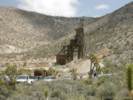
| Beck Spring Mine
| 
Beck Spring Mine |
Article records that use this photograph:
images/beckspringmine.jpg
| Blue Rock Mine
| 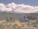
Blue Rock Mine. | I met Bill Brown, owner of the Blue Rock Mine in Macedonia Canyon, one afternoon in about 1985. He told me the Blue Rock Mine was his, and that he mined "pods" of scheelite (tungsten ore) even though there was substantial copper mineralization on his property. He also said he lived in Los Angeles, and drove out to his mine on the weekends. He kept his trailer and "jeep" at the Cima Store. I haven't seen Bill since, the roof is torn off of his cabin, and the trailer at Cima Store looks to be abandoned.
Location records that use this photograph:
Article records that use this photograph:
images/bluerockmine.jpg
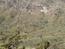
| Coliseum Mine
| 
The Coliseum Mine on the north Side of Clark Mountain. |
Location records that use this photograph:
images/2907-44.jpg
| Columbia Mine
| 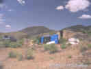
Chemical storage at the Columbia Mine. |
Article records that use this photograph:
images/colminechem.jpg
| 
The Columbia Mine. |
Article records that use this photograph:
images/colmine.jpg
| 
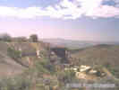
Columbia Mine as seen from the ridge above. |
Location records that use this photograph:
Article records that use this photograph:
images/3071-97.jpg
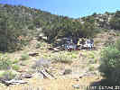
| Death Valley Mine
| 
New headframe at the Death Valley Mine. | Photograph taken 24 April 2005.
Location records that use this photograph:
Article records that use this photograph:
images/IMGP1151sm.jpg
| 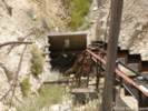
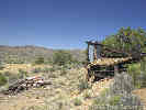
Inclined conveyor belt at the Death Valley Mine. | Photograph taken 24 April 2005.
Location records that use this photograph:
Article records that use this photograph:
images/IMGP1150sm.jpg
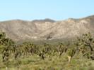
| 
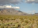
View of Cima Dome from the dump of the Death Valley Mine. | Photograph taken 24 April 2005.
Location records that use this photograph:
Article records that use this photograph:
images/IMGP1148sm.jpg
| 
View of headframe at Death Valley Mine near Cima, California | Photograph taken 24 April 2005.
Location records that use this photograph:
Article records that use this photograph:
images/IMGP1146sm.jpg
| Evening Star Mine
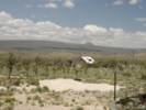
| 
The Evening Star Mine as seen from Kessler Springs (Cima) Road. | Photograph taken May 27, 2005.
Location records that use this photograph:
Article records that use this photograph:
images/IMGP1264sm.jpg
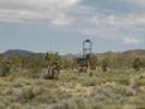
| 
View of the Evening Star Mine | Photograph taken 24 April 2005. The Evening Star Mine was the only producer of tin ore (cassiterite, tin oxide) in the eastern Mojave Desert. The mine was in production between 1939 and 1944.
Location records that use this photograph:
Article records that use this photograph:
images/IMGP1143sm.jpg
| Excelsior Mine
| 
Excelsior Mine, Kingston Range, from Excelsior Mine Road. |
Article records that use this photograph:
images/excelsiormine.jpg
| Giant Ledge Mine
| 
The "Giant Ledge," a quartz dike in Caruthers Canyon. | In the center of this photograph is the "Giant Ledge," a quartz dike that can be followed over a long distance in upper Caruthers Canyon. The Giant Ledge Mine is on the other side of the ridge from where this photograph was taken.
Location records that use this photograph:
Article records that use this photograph:
images/3182-69.jpg
| 
Giant Ledge Mine, Caruthers Canyon, New York Mountains. | This is one location for Frasera albomarginata.
Location records that use this photograph:
Article records that use this photograph:
images/giantledgemine.jpg
| Golden Quail Mine
| 
Exploration at the Golden Quail Mine: 1987. | Photographed April 1987.
Location records that use this photograph:
Article records that use this photograph:
images/198704-4-21sm.jpg
| 
Sketch map: 1987. | This is my field sketch map of the surficial geology in the vicinity of the Golden Quail Mine. sch - schist. pE - metasandstone and metaconglomerate, possibly Precambrian and correlative with the Precambrian schist and gneiss found elsewhere in the Mid Hills, not mentioned by Hewett (1956). ls - limestone, probably Goodsprings dolomite. hb - highly sheared greenish rock, probably the Cedar Canyon fault zone. gr - granite. Tv - Tertiary volcanics, probably Peach Springs Tuff or Hole-in-the-Wall Tuff.
Article records that use this photograph:
images/gqmap.jpg
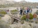
| 
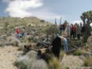
Mine shaft: 1981. | This is the shaft that Hewett (1956) notes is 250 feet deep. Kate, Scott, Matt and Linda are looking at the owl chicks in a nest about 6 feet down the shaft. The shaft is gone now as the current operators of the Golden Quail mine have dug an open pit about 30 feet deep. The stake in the right foreground marked a bore from which cores had recently been taken. None of the cores were left at the mine location.
Location records that use this photograph:
Article records that use this photograph:
images/gqshaft.jpg
| 
The open pit of the Golden Quail Mine: 1998. | This is the appearance of the Golden Quail Mine in 1998. The water is in the approximate location of the former shaft, and the area has been left a horrible mess.
Location records that use this photograph:
Article records that use this photograph:
images/3182-60.jpg
| 
Exploration at the Golden Quail Mine: 1987. | Protographed April 1987, scanned from a print 6 February 2018.
Location records that use this photograph:
Article records that use this photograph:
images/8744-19-300.jpg
| Goldhammer Mine
| 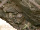
Bird eggs in a shaft of the Goldhammer Mine. | Photograph taken 24 April 2005.
Location records that use this photograph:
Article records that use this photograph:
images/IMGP1169sm.jpg
| Mollusk Mine
| 
Mollusk Mine in Mountain Pass. | Photograph taken 24 April 2005. Also known as the Mescal Mine and the Cambria Mine, the Mollusk Mine produced high-grade gold and silver ore with antimony between 1882 and 1888. The ore was processed at a 10-stamp mill at Mescal Spring.
Location records that use this photograph:
Article records that use this photograph:
images/IMGP1126sm.jpg
| Oil
| 
Oil Well near McKittrick, CA | This oil well is just west of McKittrick on California Highway 58.
Article records that use this photograph:
images/0022_3291_4597_50.jpg
| Oil drill site
| 
Oil drill site on Pinto Valley Road. | This is the remains of an exploratory oil well drilled in the late 1980's.
Article records that use this photograph:
images/0072_3301_0700_13.jpg
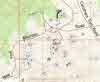
| Potosi Mine
| 
Location of Potosi Mine. | Courtesy of USGS.
Location records that use this photograph:
images/nvpotosimine.jpg
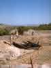
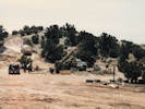
| Providence Mine
| 
Roland, Scott, Jim, Julie and Gray in front of the powder house at the Providence Mine. | The Providence Mine is in the extreme north end of the Providdence Mountains, and is reached by way of Globe Canyon, and Summit Springs.
Location records that use this photograph:
Article records that use this photograph:
images/1621-18.jpg
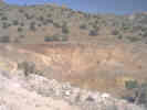
| Silver Buddy Mine
| 
Prospect trenches at the Silver Buddy Mine. | These horrible gashes were made in the hillside by the miners when they were prospecting at the Silver Buddy Mine. They were probably made by a caterpillar tractor in a few hours, but will require many more years to heal.
Location records that use this photograph:
Article records that use this photograph:
images/2907-08.jpg
| 
Debris around the Silver Buddy Mine. | Photograph taken in May, 1999.
Location records that use this photograph:
Article records that use this photograph:
images/3526-96.jpg
| 
Ore bin and equipment dump at the Silver Buddy Mine. | Photograph taken in May, 1999.
Article records that use this photograph:
images/3526-95.jpg
| 
Aerial photograph of prospect trenches at the Silver Buddy Mine. | The Silver Buddy Mine is west of Wild Horse Canyon Road. Apparently while prospecting, the former mine operators dug four deep trenches in the hill side. These trenches are clearly visible in this aerial photograph and when on the ground. The scars may never heal within a human lifetime.
Location records that use this photograph:
Article records that use this photograph:
images/DOQSilverBuddy.jpg
| Silverado-Tungstite claims
| 
Silverado-Tungstite claims | Photograph taken 24 April 2005. Silver was shipped from the Silverado Claim before 1900. The Tungstite skarn is along a dolomite/granite contact containing epidote, garnet, and scheelite (calcium tungstate); it was prospected intil 1951. The four rock ruins were apparently housing and an assay building. Also nearby is rockwork probably associated with an old regional freight road.
Location records that use this photograph:
Article records that use this photograph:
images/IMGP1128sm.jpg
| 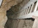
Looking down the main shaft of the Silverado Claim. | Photograph taken 24 April 2005.
Location records that use this photograph:
Article records that use this photograph:
images/IMGP1133sm.jpg
| Standard No. 1 Mine Camp
| 
View of the Standard No. 1 Mine Camp. | Photograph taken 24 April 2005. The Excelsior was located in 1896 and produced copper with gold and silver between 1902 and 1908 from a skarn that contained magnetite, chalcopyrite, and scheelite. Before 1905, ore from the Standard No. 1 was hauled by wagon to a smelter at Needles. Rail service was established to Cima in 1905, and ore was then hauled by 16-horse-team wagons to rail cars bound for smelters in Salt Lake, Utah.
Location records that use this photograph:
Article records that use this photograph:
images/IMGP1137sm.jpg
| Vulcan Iron Mine
| 
View of the Vulcan Iron Mine from Kelbaker Road | Photograph taken 24 April 2005.
Location records that use this photograph:
Article records that use this photograph:
images/IMGP1173sm.jpg
|
| Date and time this article was prepared: 4/27/2024 3:33:50 PM | |||||||||||||||||||