Eastern Mojave Vegetation
Tom Schweich
|
Eastern Mojave Vegetation
| Effects of the Hackberry Complex Fire in Mojave National Preserve, June 22-25, 2005. |
|
Tom Schweich |

Topics in this Article: Effects Plants Literature Cited |
This page is a work-in-progress as I put together the information I can assemble about this devastating fire. | |||||||||||||||||||||||||||||||||||||||||||||||||||||||||||||||||||||||||||||||||||||||||||||||||||||||||||||||||||||||||||||||||||||||||||||||||||||||||||||||||||||||||||||
|
Literature Cited:
|
The Hackberry Complex fires began on the Mojave National Preserve on June 22, 2005 at approximately 12:00 Noon as a dry lightning storm rolled through the Preserve. Three separate fires on Hackberry Mountain were reported by a San Bernardino County Road Department that eventually burned together to become the Hackberry Fire. At approximately 5:00 PM hours a second storm rolled through the Preserve and two additional fires were reported near the Hole-in-the-Wall Visitor Center. These fires became the Narrow and Wild Horse fires. The Brant Fire was reported at 6:00 PM and the Ranch Fire was reported by residents at 7:00 PM. At the peak of the incident there were 1,133 personnel on the fire including 5 helicopters, four air tankers, two single-engine air tankers (SEAT), and 15 engine crews. A total of 70,736 acres were burned. The cost to date to suppress the Hackberry Complex fires is approximately 3.1 million dollars. | |||||||||||||||||||||||||||||||||||||||||||||||||||||||||||||||||||||||||||||||||||||||||||||||||||||||||||||||||||||||||||||||||||||||||||||||||||||||||||||||||||||||||||||
|
Literature Cited:
|
Vegetation resources were impacted to varying degrees as fire intensities varied across the landscape. Combinations of wind, fuel, slope and plume-driven fire behavior contributed to difficult suppression conditions. Thunderstorms moving through the area caused downburst winds with little to no precipitation over the fire area. Suppression resources were pulled back to safety zones several times during the incident. The Mojave Desert was lush with vegetation following a record-setting winter and therefore rates of spread were extreme. | |||||||||||||||||||||||||||||||||||||||||||||||||||||||||||||||||||||||||||||||||||||||||||||||||||||||||||||||||||||||||||||||||||||||||||||||||||||||||||||||||||||||||||||
|
Literature Cited:
|
Hackberry Complex fire suppression actions included construction of 2.3 miles of hand line. Fire suppression forces impacted 47 miles of roads. In addition, associated suppression actions included 2 fire camps, and multiple helispots. Approximately 19,129 gallons of retardant, 30,000 gallons of foam, and 96,010 gallons of wet water was delivered by aircraft. | |||||||||||||||||||||||||||||||||||||||||||||||||||||||||||||||||||||||||||||||||||||||||||||||||||||||||||||||||||||||||||||||||||||||||||||||||||||||||||||||||||||||||||||
| The Park Service has posted a map showing the spread of the fire at http://www.nps.gov/moja/hackberry.pdf | ||||||||||||||||||||||||||||||||||||||||||||||||||||||||||||||||||||||||||||||||||||||||||||||||||||||||||||||||||||||||||||||||||||||||||||||||||||||||||||||||||||||||||||||
|
|
Effects | |||||||||||||||||||||||||||||||||||||||||||||||||||||||||||||||||||||||||||||||||||||||||||||||||||||||||||||||||||||||||||||||||||||||||||||||||||||||||||||||||||||||||||||
|
|
Wild Horse Mesa | |||||||||||||||||||||||||||||||||||||||||||||||||||||||||||||||||||||||||||||||||||||||||||||||||||||||||||||||||||||||||||||||||||||||||||||||||||||||||||||||||||||||||||||
|
Other articles:
Locations:
Wild Horse Mesa.
|
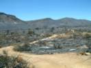
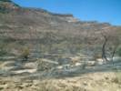
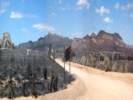
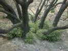
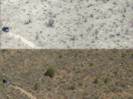
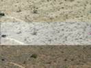
By the fire map, the entire top of Wild Horse Mesa burned, as well as the entire north face of the mesa. However, as you can see in the left middle of this photo, the area underlain by the white soil (Winkler Formation, lacustrine limestone) did not burn. | |||||||||||||||||||||||||||||||||||||||||||||||||||||||||||||||||||||||||||||||||||||||||||||||||||||||||||||||||||||||||||||||||||||||||||||||||||||||||||||||||||||||||||||
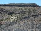 North face of Wild Horse Mesa after the Hackberry Complex Fire North face of Wild Horse Mesa after the Hackberry Complex Fire
|
Some areas on the slopes of the mesa did not burn, presumably because of the sparse vegetation. My plots in Frasera albomarginata are found in this area, and may not have burned. | |||||||||||||||||||||||||||||||||||||||||||||||||||||||||||||||||||||||||||||||||||||||||||||||||||||||||||||||||||||||||||||||||||||||||||||||||||||||||||||||||||||||||||||
|
|
Wild Horse Canyon | |||||||||||||||||||||||||||||||||||||||||||||||||||||||||||||||||||||||||||||||||||||||||||||||||||||||||||||||||||||||||||||||||||||||||||||||||||||||||||||||||||||||||||||
Lower Wild Horse Canyon | ||||||||||||||||||||||||||||||||||||||||||||||||||||||||||||||||||||||||||||||||||||||||||||||||||||||||||||||||||||||||||||||||||||||||||||||||||||||||||||||||||||||||||||||
|
Other articles:
Locations:
Wild Horse Canyon.
|
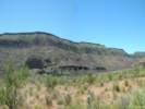
The fire came down this face of Wild Horse Mesa in the lower canyon, leaving patchy areas unburned. Photograph taken June 27, 2005 by Phil Woodall. | |||||||||||||||||||||||||||||||||||||||||||||||||||||||||||||||||||||||||||||||||||||||||||||||||||||||||||||||||||||||||||||||||||||||||||||||||||||||||||||||||||||||||||||
|
Other articles:
Locations:
Wild Horse Canyon.
|
||||||||||||||||||||||||||||||||||||||||||||||||||||||||||||||||||||||||||||||||||||||||||||||||||||||||||||||||||||||||||||||||||||||||||||||||||||||||||||||||||||||||||||||
|
Other articles:
Locations:
Wild Horse Canyon.
|
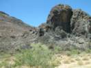
There is a rock outcrop in the mid-section of Wild Horse Canyon. This is an identified archeological site and, supposedley, site of some rock rings, although I have never found them. At this location the fire burned right down to the wash and Wild Horse Canyon Road. | |||||||||||||||||||||||||||||||||||||||||||||||||||||||||||||||||||||||||||||||||||||||||||||||||||||||||||||||||||||||||||||||||||||||||||||||||||||||||||||||||||||||||||||
|
Other articles:
Locations:
Wild Horse Canyon.
|
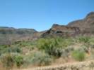
The upper section of lower Wild Horse Canyon was completely burned by the Hackberry Complex Fire, June 22-25, 2005, except for some small patches on the other side of the wash and up near the rim of the mesa. | |||||||||||||||||||||||||||||||||||||||||||||||||||||||||||||||||||||||||||||||||||||||||||||||||||||||||||||||||||||||||||||||||||||||||||||||||||||||||||||||||||||||||||||
|
Other articles:
Locations:
Wild Horse Canyon.
|
The upper Wild Horse Canyon has several areas with well-developed pediments. This one burned completely in the Hackberry Complex Fire. | |||||||||||||||||||||||||||||||||||||||||||||||||||||||||||||||||||||||||||||||||||||||||||||||||||||||||||||||||||||||||||||||||||||||||||||||||||||||||||||||||||||||||||||
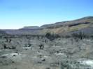
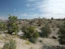
Upper Wild Horse Canyon | ||||||||||||||||||||||||||||||||||||||||||||||||||||||||||||||||||||||||||||||||||||||||||||||||||||||||||||||||||||||||||||||||||||||||||||||||||||||||||||||||||||||||||||||
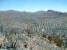 Looking east across upper Wild Horse Canyon from the hill above Winkler's Cabin. Looking east across upper Wild Horse Canyon from the hill above Winkler's Cabin.
|
The entire upper Wild Horse Canyon burned except for small patches here and there. From this photograph, it also looks like my experimental plot in Salvia dorrii has burned as well. | |||||||||||||||||||||||||||||||||||||||||||||||||||||||||||||||||||||||||||||||||||||||||||||||||||||||||||||||||||||||||||||||||||||||||||||||||||||||||||||||||||||||||||||
|
|
Winklers Cabin | |||||||||||||||||||||||||||||||||||||||||||||||||||||||||||||||||||||||||||||||||||||||||||||||||||||||||||||||||||||||||||||||||||||||||||||||||||||||||||||||||||||||||||||
|
Locations:
Winklers Cabin.
|
Winklers Cabin is a miner's cabin in the upper reaches of Wild Horse Canyon. Often visited by those "in the know," it had a sign over the door saying, "Leave what you can, take what you need," and a log book inside with writings from many year's visitors. | |||||||||||||||||||||||||||||||||||||||||||||||||||||||||||||||||||||||||||||||||||||||||||||||||||||||||||||||||||||||||||||||||||||||||||||||||||||||||||||||||||||||||||||
|
Locations:
Winklers Cabin.
|
Unfortunately, Winklers Cabin was burned to the ground by the Wild Horse fire of the Hackberry Complex. Phil Woodall, a frequent visitor to the cabin, visited on June 27, 2005, and took this photo. | |||||||||||||||||||||||||||||||||||||||||||||||||||||||||||||||||||||||||||||||||||||||||||||||||||||||||||||||||||||||||||||||||||||||||||||||||||||||||||||||||||||||||||||
 Entrance to the Blue Jay Mine, caved following the Hackberry Fire Complex. Entrance to the Blue Jay Mine, caved following the Hackberry Fire Complex.
|
It appears that the shoring around the entrance to the Blue Jay Mine at Winkler's Cabin burned substantially, allowing additional collapse. | |||||||||||||||||||||||||||||||||||||||||||||||||||||||||||||||||||||||||||||||||||||||||||||||||||||||||||||||||||||||||||||||||||||||||||||||||||||||||||||||||||||||||||||
|
|
Between Wild Horse Canyon and Lobo Point -- My Plot in Salvia dorrii | |||||||||||||||||||||||||||||||||||||||||||||||||||||||||||||||||||||||||||||||||||||||||||||||||||||||||||||||||||||||||||||||||||||||||||||||||||||||||||||||||||||||||||||
|
Other articles:
|
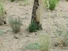
In April, 1996, I established a plot along the access road to Lobo Point. This plot was 5 m wide by 50 m long. I identified and measured every plant in the plot. | |||||||||||||||||||||||||||||||||||||||||||||||||||||||||||||||||||||||||||||||||||||||||||||||||||||||||||||||||||||||||||||||||||||||||||||||||||||||||||||||||||||||||||||
 White 40 in April 1998 White 40 in April 1998
 Population of F. albomarginata and Salvia dorrii by observation date. Population of F. albomarginata and Salvia dorrii by observation date.
|
In April, 1997, I went back and individually staked every Salvia dorrii in the plot. The El Niño year of 1998 saw the establishment of many seedlings. Many of the seedlings survived until the drought years of 2002-2003, when every seedling perished. I thought this was a significant finding that a population of about 50 plants could generate about 70 seedlings, none of which survived to bloom and set seed. | |||||||||||||||||||||||||||||||||||||||||||||||||||||||||||||||||||||||||||||||||||||||||||||||||||||||||||||||||||||||||||||||||||||||||||||||||||||||||||||||||||||||||||||
 Salvia dorriiWhite 38 on May 28, 2005. Salvia dorriiWhite 38 on May 28, 2005.
|
In 2004, being a good year, the few surviving Salvia dorrii bloomed, raising the prospect of seedlings in 2005. | |||||||||||||||||||||||||||||||||||||||||||||||||||||||||||||||||||||||||||||||||||||||||||||||||||||||||||||||||||||||||||||||||||||||||||||||||||||||||||||||||||||||||||||
 Before and after photo (warning, large image: 1.8 MB) Before and after photo (warning, large image: 1.8 MB)
 Before and after photo. Before and after photo.
|
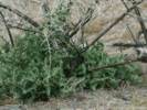
Unfortunately, though, the plot burned completely in the Hackberry Complex fire. | |||||||||||||||||||||||||||||||||||||||||||||||||||||||||||||||||||||||||||||||||||||||||||||||||||||||||||||||||||||||||||||||||||||||||||||||||||||||||||||||||||||||||||||
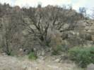
 My plot in Frasera albomarginata after the Hackberry Complex Fire My plot in Frasera albomarginata after the Hackberry Complex Fire
 The Hackberry Complex Fire burned quite close to my plot. The Hackberry Complex Fire burned quite close to my plot.
|
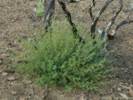
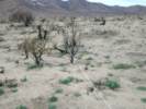
My plots in Frasera albomarginata on the north face of Wild Horse Mesa and the south face of Pinto Mountain were not burned, even though the fire came quite close. | |||||||||||||||||||||||||||||||||||||||||||||||||||||||||||||||||||||||||||||||||||||||||||||||||||||||||||||||||||||||||||||||||||||||||||||||||||||||||||||||||||||||||||||
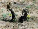
 Former plot in Salvia dorrii Former plot in Salvia dorrii
|
The above ground parts of every plant were destroyed by the fire. | |||||||||||||||||||||||||||||||||||||||||||||||||||||||||||||||||||||||||||||||||||||||||||||||||||||||||||||||||||||||||||||||||||||||||||||||||||||||||||||||||||||||||||||
|
Other articles:
|
||||||||||||||||||||||||||||||||||||||||||||||||||||||||||||||||||||||||||||||||||||||||||||||||||||||||||||||||||||||||||||||||||||||||||||||||||||||||||||||||||||||||||||||
| This effectively terminates my study of population dynamics in this population of S. dorrii. | ||||||||||||||||||||||||||||||||||||||||||||||||||||||||||||||||||||||||||||||||||||||||||||||||||||||||||||||||||||||||||||||||||||||||||||||||||||||||||||||||||||||||||||||
| The fire in my previously measured plot does, however, raise some new possibilities. Here are some new questions that I may try to answer by continuing to work in this plot: | ||||||||||||||||||||||||||||||||||||||||||||||||||||||||||||||||||||||||||||||||||||||||||||||||||||||||||||||||||||||||||||||||||||||||||||||||||||||||||||||||||||||||||||||
| ||||||||||||||||||||||||||||||||||||||||||||||||||||||||||||||||||||||||||||||||||||||||||||||||||||||||||||||||||||||||||||||||||||||||||||||||||||||||||||||||||||||||||||||
| So I think my plan will be, assuming agreeement by the Park Service, to study fire response in a desert scrub population. | ||||||||||||||||||||||||||||||||||||||||||||||||||||||||||||||||||||||||||||||||||||||||||||||||||||||||||||||||||||||||||||||||||||||||||||||||||||||||||||||||||||||||||||||
|
|
Lobo Point | |||||||||||||||||||||||||||||||||||||||||||||||||||||||||||||||||||||||||||||||||||||||||||||||||||||||||||||||||||||||||||||||||||||||||||||||||||||||||||||||||||||||||||||
|
|
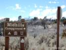
Mid Hills Campground | |||||||||||||||||||||||||||||||||||||||||||||||||||||||||||||||||||||||||||||||||||||||||||||||||||||||||||||||||||||||||||||||||||||||||||||||||||||||||||||||||||||||||||||
|
Other articles:
Locations:
Mid Hills Campground.
|
||||||||||||||||||||||||||||||||||||||||||||||||||||||||||||||||||||||||||||||||||||||||||||||||||||||||||||||||||||||||||||||||||||||||||||||||||||||||||||||||||||||||||||||
|
Locations:
Mid Hills Campground.
|
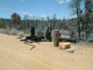
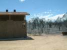
The information kiosk at the Mid Hills Campground burned to the ground. | |||||||||||||||||||||||||||||||||||||||||||||||||||||||||||||||||||||||||||||||||||||||||||||||||||||||||||||||||||||||||||||||||||||||||||||||||||||||||||||||||||||||||||||
|
Locations:
Mid Hills Campground.
|
||||||||||||||||||||||||||||||||||||||||||||||||||||||||||||||||||||||||||||||||||||||||||||||||||||||||||||||||||||||||||||||||||||||||||||||||||||||||||||||||||||||||||||||
|
Locations:
Mid Hills Campground.
|
||||||||||||||||||||||||||||||||||||||||||||||||||||||||||||||||||||||||||||||||||||||||||||||||||||||||||||||||||||||||||||||||||||||||||||||||||||||||||||||||||||||||||||||
|
Other articles:
Locations:
Mid Hills Campground.
|
||||||||||||||||||||||||||||||||||||||||||||||||||||||||||||||||||||||||||||||||||||||||||||||||||||||||||||||||||||||||||||||||||||||||||||||||||||||||||||||||||||||||||||||
|
Other articles:
Locations:
Round Valley.
|
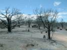
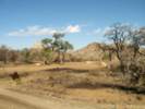
This panorama, taken June 27, 2005, after the Hackberry Complex Fire of June 22-25, 2005, shows that much of Round Valley burned as well as a good portion of Pinto Mountain. | |||||||||||||||||||||||||||||||||||||||||||||||||||||||||||||||||||||||||||||||||||||||||||||||||||||||||||||||||||||||||||||||||||||||||||||||||||||||||||||||||||||||||||||
|
|
Plants | |||||||||||||||||||||||||||||||||||||||||||||||||||||||||||||||||||||||||||||||||||||||||||||||||||||||||||||||||||||||||||||||||||||||||||||||||||||||||||||||||||||||||||||
|
|
Rare Plants | |||||||||||||||||||||||||||||||||||||||||||||||||||||||||||||||||||||||||||||||||||||||||||||||||||||||||||||||||||||||||||||||||||||||||||||||||||||||||||||||||||||||||||||
| Mojave National Preserve is a refuge for 103 species of rare plants as described by the State of california in conjunction with the California Native Plant Society (CNPS). Approximately 38 may have been burned over by the Hackberry Complex. There is limited information regarding the potential effects of the fire to these species. The Burn Area Emergency Response Team has prioritized ten species for focused monitoring with the potential for future treatments based upon assessment information. | ||||||||||||||||||||||||||||||||||||||||||||||||||||||||||||||||||||||||||||||||||||||||||||||||||||||||||||||||||||||||||||||||||||||||||||||||||||||||||||||||||||||||||||||
|
|
Response to Fire | |||||||||||||||||||||||||||||||||||||||||||||||||||||||||||||||||||||||||||||||||||||||||||||||||||||||||||||||||||||||||||||||||||||||||||||||||||||||||||||||||||||||||||||
| Plants that definitely resprout from roots | ||||||||||||||||||||||||||||||||||||||||||||||||||||||||||||||||||||||||||||||||||||||||||||||||||||||||||||||||||||||||||||||||||||||||||||||||||||||||||||||||||||||||||||||
| Yucca baccata Torrey | ||||||||||||||||||||||||||||||||||||||||||||||||||||||||||||||||||||||||||||||||||||||||||||||||||||||||||||||||||||||||||||||||||||||||||||||||||||||||||||||||||||||||||||||
| Symphoricarpos longiflorus A. Gray. | ||||||||||||||||||||||||||||||||||||||||||||||||||||||||||||||||||||||||||||||||||||||||||||||||||||||||||||||||||||||||||||||||||||||||||||||||||||||||||||||||||||||||||||||
| Chamaesyce albomarginata (Torrey & A. Gray) Small. | ||||||||||||||||||||||||||||||||||||||||||||||||||||||||||||||||||||||||||||||||||||||||||||||||||||||||||||||||||||||||||||||||||||||||||||||||||||||||||||||||||||||||||||||
|
Other articles:
|
Canyon Live Oak (Quercus chrysolepis Liebm.) | |||||||||||||||||||||||||||||||||||||||||||||||||||||||||||||||||||||||||||||||||||||||||||||||||||||||||||||||||||||||||||||||||||||||||||||||||||||||||||||||||||||||||||||
| Dalea searlsiae (A. Gray) Barneby. | ||||||||||||||||||||||||||||||||||||||||||||||||||||||||||||||||||||||||||||||||||||||||||||||||||||||||||||||||||||||||||||||||||||||||||||||||||||||||||||||||||||||||||||||
| Salazaria mexicana Torrey. | ||||||||||||||||||||||||||||||||||||||||||||||||||||||||||||||||||||||||||||||||||||||||||||||||||||||||||||||||||||||||||||||||||||||||||||||||||||||||||||||||||||||||||||||
| Sphaeralcea ambigua A. Gray. | ||||||||||||||||||||||||||||||||||||||||||||||||||||||||||||||||||||||||||||||||||||||||||||||||||||||||||||||||||||||||||||||||||||||||||||||||||||||||||||||||||||||||||||||
| Mirabilis multiflora (Torrey) A. Gray. | ||||||||||||||||||||||||||||||||||||||||||||||||||||||||||||||||||||||||||||||||||||||||||||||||||||||||||||||||||||||||||||||||||||||||||||||||||||||||||||||||||||||||||||||
| Fraxinus anomala S. Watson. | ||||||||||||||||||||||||||||||||||||||||||||||||||||||||||||||||||||||||||||||||||||||||||||||||||||||||||||||||||||||||||||||||||||||||||||||||||||||||||||||||||||||||||||||
| Prunus fasciculata (Torrey) A. Gray. | ||||||||||||||||||||||||||||||||||||||||||||||||||||||||||||||||||||||||||||||||||||||||||||||||||||||||||||||||||||||||||||||||||||||||||||||||||||||||||||||||||||||||||||||
Keckiella antirrhinoides (Benth.) Straw ssp. microphylla,/i> (A. Gray) N. Holmgren.
|
|
Other articles:
Verbena gooddingii Briq.
|
|
Plants that may resprout depending upon possible damage
|
|
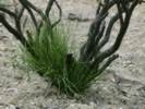
Echinocereus triglochidiatus Engelm.
|
|
Other articles:
|
|
Other articles:
|
|
Other articles:
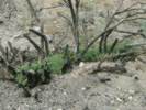
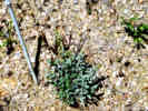
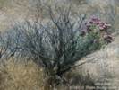
Lycium cooperi A. Gray. | I'm pretty sure that this is L. cooperi, but the leaves are very large, much larger than I usually see on this plant. Perhaps the size of the leaves is related to the plant having been burned.
|
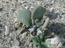 Beavertail (Opunita basilaris) sprouting after a fire. Beavertail (Opunita basilaris) sprouting after a fire.
Opuntia basilaris Engelm. & J. Bigelow.
|
|
 Pancake Cactus (Opuntia chlorotica) resprouting after the Hackberry Complex Fire. Pancake Cactus (Opuntia chlorotica) resprouting after the Hackberry Complex Fire.
Opuntia chlorotica Engelm. & J. Bigelow.
|
|
Other articles:
Purshia tridentata (Pursh) DC var. glandulosa (Curran) M. E. Jones.
|
|
Other articles:
Yucca brevifolia Engelm.
|
|
Other articles:
Yucca schidigera K. E. Ortgies.
|
|
Plants that were not observed resprouting:
|
|
Opuntia acanthocarpa Engelm. & J. Bigelow var. coloradensis L. Benson.
|
|
Juniperus osteosperma (Torrey) Little.
|
|
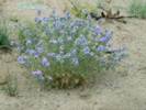
Salvia dorrii (Kellogg) Abrams.
|
|
Pinus monophylla Torrey & Fremont.
|
|
Coleogyne ramosissima Torrey.
|
|
| Recovery From Fire
|
Other articles:
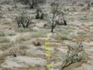
On April 29-30, 1996, I measured a transect near Lobo Point. The purpose was to develop a quantitative understanding of the plant species growing on the bajada north of Lobo Point. Since I measured every perennial plant, it was possible to prepare absolute measures of density and coverage by species. The results are shown in my page: Transect 5 in Blackbrush Scrub Near Lobo Point, Mojave National Preserve, California.
|
|
The transect was burned completely by the Hackberry Complex Fire.
|
|
On June 7-8, 2006, I measured the same transect again. Once again, I measured every perennial plant, skipping over the dried annuals. The resulting statistics are shown below.
|
|
|
|
| Literature CitedA list of all literature cited by this web site can be found in the Bibliography. |
Burn Area Emergency Response Team. 2005.
Burned Area Emergency Stabilization Plan: Hackberry Complex.
Primm, Nevada: National-Interagency Burned Area Emergency Response Team, July 5, 2005.
|
If you have a question or a comment you may write to me at:
tomas@schweich.com
I sometimes post interesting questions in my FAQ, but I never disclose your full name or address.
|
|
Date and time this article was prepared: 9/22/2024 4:41:47 PM |